File:TD3-book-Aanthirin Region Map.png
The UESPWiki – Your source for The Elder Scrolls since 1995
TD3-book-Aanthirin_Region_Map.png (512 × 512 pixels, file size: 268 KB, MIME type: image/png)
Summary[edit]
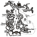
A political map of the Aanthirin region, showing the Empire, Indoril, Temple, and Hlaalu holdings
Licensing[edit]
| This file is ineligible for copyright and therefore in the public domain, because it consists entirely of information that is common property and contains no original authorship. |
File history
Click on a date/time to view the file as it appeared at that time.
| Date/Time | Thumbnail | Dimensions | User | Comment | |
|---|---|---|---|---|---|
| current | 14:40, 21 November 2024 |  | 512 × 512 (268 KB) | Ohnoitsmangofett (talk | contribs) | current version |
| 14:59, 26 November 2018 |  | 512 × 512 (298 KB) | Dillonn241 (talk | contribs) | A political map of the Aanthirin region, showing the Empire, Indoril, Temple, and Hlaalu holdings Category:Tes3Mod-Tamriel Data-Book Images |
- You cannot overwrite this file.
File usage
The following 3 pages link to this file:
